 Примерный вес вещей
 Предварительный расчет доставки в Украину


| Вид отправки | USD | Сроки |
|---|


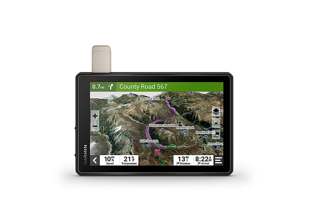
Roam the unknown with Tread – Overland Edition. It’s the rugged all-terrain navigator with an 8” ultrabright display made for every overlanding expedition. Enjoy turn-by-turn trail navigation for traversing unpaved roads and trails. (Limitations may exist in map data for some road and trail route suggestions. Always defer to all posted road signs and conditions during vehicle operation. The Garmin OpenStreetMap products are intended to be used only as a supplementary travel aid and must not be used for any purpose requiring precise measurement of direction, distance, location or topography.) Custom street routing takes into account the size and weight of your rig. (Not available in all areas. Entering your vehicle’s profile characteristics does not guarantee your vehicle’s characteristics will be accounted for in all route suggestions. Always defer to all posted road signs and road conditions.) The navigator includes preloaded topography, subscription-free BirdsEye Satellite Imagery, iOverlander points of interest and Ultimate Public Campgrounds, so you won’t need a signal to route to the best-established, wild and dispersed campsites. With an active satellite subscription, built-in inReach technology offers global satellite communication, two-way text messaging, location sharing, and interactive SOS (Some jurisdictions regulate or prohibit the use of satellite communications devices). Pair your device to the Tread app on your compatible smartphone to track up to 20 friends using the Group Ride Mobile feature and plan routes with the same maps and route preferences that you have on the Tread device. (Tracking via Group Ride Mobile requires the Tread app running on your and each friend’s compatible smartphone with BLUETOOTH technology and an active cellular connection.)
Быстрая регистрация
Как это работает? Схема покупки в 5 шагов
-
Выбор товара
 1
1 -
Оплата товара
 2
2 -
Получение на

складе в США3 -
3Формирование посылки в Украину
 44
44 -
Самолет

от 7 днейМорем от 24 дней 55
55 -
Получение посылки на

Новой Почте